The 2023 Spring Wildfires state of emergency expires on June 3, 2023 at 11:59 p.m. A provincial state of emergency in Alberta automatically expires after 28 days.
With the wildfire situation continuing to improve, Alberta’s provincial state of emergency is expiring but all resourcing and support remains in place.
Today was the last scheduled media availability regarding the Alberta wildfire situation, but these situation updates will continue to be issued each day. Future media availabilities will be held if circumstances change and there are significant updates to report.
For more information, please visit alberta.ca/emergency for information or call 310-4455, now available 24-7.
May 25 WILDFIRE UPDATE
Wildfire Situation
The recent rain is helping firefighters make good progress on all wildfires in the Slave Lake Forest Area. Firefighters are reporting that 30 to 60 millimetres of rain was received on all wildfires over the last few days and the fire behavior has been reduced to smouldering ground fires at this time but could pick-up as we head into the weekend with warmer temperatures.
Grizzly Complex – SWF057 (Grizzly Ridge Wildfire), SWF063 (East Prairie, Gilwood & Banana Belt Wildfire), SWF064 (Blue Lake Wildfire)
SWF-057 is located approximately 26 kilometres south of Kinuso and over 30 kilometers southwest of the Town of Slave Lake. The wildfire is classified as out of control and has burned an estimated 16,728 hectares. Firefighters continue to extinguish hotspots along Highway 33 and the south perimeter of the wildfire.
SWF-063 islocated approximately seven kilometers south of High Prairie and sixteen kilometers northwest of Swan Hills. The wildfire is classified as burning out of control and has burned an estimated 123,670 hectares. In the northwestern portion of the wildfire, firefighters continue to extinguish hotspots in the Banana Belt and East Prairie Metis Settlement areas. Heavy equipment has completed 85% of the fire guard on the southeast end of the wildfire. Heavy equipment will continue to build fire guard on the east side of the wildfire heading north.
East Prairie Metis Settlement has lifted their evacuation order and is now under a four-hour evacuation alert. Visit https://www.alberta.ca/alberta-emergency-alert.aspx
The Town of Swan Hills has lifted the evacuation order and is now under a four-hour evacuation alert. Visit the Town of Swan Hills Facebook page for more information https://www.facebook.com/TownofSwanHills
SWF-064 is located over 40 kilometers northwest of Swan Hills. The wildfire is classified as out of control and has burned approximately 40,060 hectares. This wildfire has connected to SWF-063 to the north. Multiple heavy equipment groups are working on this wildfire and additional heavy equipment groups are expected to be deployed as needed.
There is a total of 98 firefighters, 23 support staff and 105 pieces of heavy equipment on the Saulteaux and Grizzly Complexes. Today, 23 helicopters will be conducting bucketing operations on major hotspot areas. In addition, 95 military personnel will be helping with transportation, safety, and various firefighting duties.
SWF068 and PWF038 (Kimiwan Complex/Peavine Wildfire)
SWF068 is classified as Out of Control (OC). As air quality has improved, air operations have resumed. More accurate perimeters are being established, including updated estimated fire size, which is now 119,985 ha. The SWF068 wildfire is currently 43 per cent contained. Firefighters continue to work in the north end and east flank of the wildfire extinguishing hotspots and seeking opportunities for heavy equipment access. Resumed air operations enables increased support for heavy equipment groups, which continue to build fire guard around the fire excursion on the west side of the fire, north of the Town of McLennan, on the southern end of the fire, north of Peavine Metis Settlement, and at the fire’s eastern flank. Work to link dozer guards on the east flank from the south and north is continuing. Resources on the fire include 41 pieces of heavy equipment, 61 unit crew, five hac crew, 81 firetac, and 23 other single resource firefighters.
Saulteaux Complex – SWF085, SWF086 and SWF087
These wildfires are located approximately five kilometres northwest of Smith and 30 kilometres east of the Town of Slave Lake. SWF086 is still classified as out of control at approximately 4,802 ha.
SWF085 (approx 39 ha) and SWF087 (appox 1,036 ha) have been classified as being held. Being held means that the fires are not expected to grow beyond established boundaries.
Structure protection equipment is still in place along the Old Smith Highway and wildland firefighters with water trucks continue to work together with local Fire Departments patrolling for and extinguishing ground fires in the area. Heavy equipment continues to build fire guard on the north side of SWF086 and firefighters are working along the wildfire perimeter extinguishing ground fires. Heavy equipment has established guard all around the north excursion from earlier this week.
Crews are walking the fire perimeter of SWF086 looking for and extinguishing smouldering hotspots. Firefighters will be working to prevent spread west of the Otauwau River by creating fire guard with heavy equipment.
The MD of Lesser Slave River has lifted the evacuation order and replaced it with a eight hour evacuation warning for all residents along Old Smith Highway from Township Road 715 (Smith Bridge) to Range Road 45 (Tollenaars Bridge). An eight hour evacuation warning has been issued for all residents in Hondo, the hamlet of Smith, and all properties between. It also includes the Fawcett Lake Resort, Broken Paddle and all residents between Fawcett Lake and Smith bridge on township road 715. Mitsue Industrial Park area is also on an eight hour evacuation notice.
Evacuation alert information https://www.alberta.ca/alberta-emergency-alert.aspx
Highway 2 is open. For the latest road conditions visit https://511.alberta.ca/#:Alerts
May 24 @ 3 PM WILDFIRE UPDATE
Wildfire Situation
The recent rain is helping firefighters make good progress on all wildfires in the Slave Lake Forest Area. Firefighters are reporting that 30 to 50 millimeters of rain was received on all wildfires and the fire behavior has been reduced to smoldering ground fires.
Grizzly Complex – Grizzly Complex – SWF057 (Grizzly Ridge Wildfire), SWF063 (East Prairie, Gilwood & Banana Belt Wildfire), SWF064 (Blue Lake Wildfire)
SWF-057 is located approximately 26 kilometers south of Kinuso and over 30 kilometers southwest of the Town of Slave Lake. The wildfire is classified as out of control and has burned an estimated 16,728 hectares. Firefighters continue to extinguish hotspots along Highway 33 and the south perimeter of the wildfire.
SWF-063 islocated approximately seven kilometers south of High Prairie and sixteen kilometers northwest of Swan Hills. The wildfire is classified as burning out of control and has burned an estimated 123,670 hectares. In the northwestern portion of the wildfire, firefighters continue to extinguish hotspots in the Banana Belt and East Prairie Metis Settlement areas. Heavy equipment has completed 85% of the fire guard on the southeast end of the wildfire. Heavy equipment will continue to build fire guard on the east side of the wildfire heading north.
East Prairie Metis Settlement remains under an evacuation order. Visit https://www.alberta.ca/alberta-emergency-alert.aspx
The Town of Swan Hills has lifted the evacuation order and is now under a four-hour evacuation alert. Visit the Town of Swan Hills Facebook page for more information https://www.facebook.com/TownofSwanHills
SWF-064 is located over 40 kilometers northwest of Swan Hills. The wildfire is classified as out of control and has burned approximately 40,060 hectares. This wildfire has connected to SWF-063 to the north. One heavy equipment group is working on this wildfire and additional heavy equipment groups are expected to be deployed.
There are a total of 110 firefighters, 28-member incident command team and 114 pieces of heavy equipment on the Saulteaux and Grizzly Complexes. Today 21 helicopters will be conducting bucketing operations when visibility will allow them to. There are also 95 military personnel helping with transportation, safety, and various firefighting duties.
SWF068 and PWF038 (Kimiwan/Peavine Complex Wildfire)
SWF068 is located approximately six kilometers northwest of Peavine Metis Settlement. Firefighting operations are being conducted by the Peace River Forest Area. Peavine Metis Settlement remains under an evacuation order. Visit https://www.alberta.ca/alberta-emergency-alert.aspx For more information on this wildfire visit the Peace River Wildfire Update.
Saulteaux Complex – SWF085, SWF086 and SWF087
These wildfires are located approximately five kilometers northwest of Smith and 30 kilometers east of the Town of Slave Lake. SWF086 is still classified as out of control at approximately 4,802 ha. SWF085 approximately 39 ha and SWF087 approximately 1,036 have been classified as being held. Being held means that the fires are not expected to grow beyond established boundaries.
Structure protection equipment is still in place along the Old Smith Highway and wildland firefighters with water trucks continue to work together with local Fire Departments patrolling for and extinguishing ground fires in the area. Heavy equipment continues to build fire guard on the north and west side of SWF068 and firefighters are working along the wildfire perimeter extinguishing ground fires.
The MD of Lesser Slave River has lifted the evacuation order and replaced it with a eight hour evacuation warning for all residents along Old Smith Highway from Township Road 715 (Smith Bridge) to Range Road 45 (Tollenaars Bridge). An eight-hour evacuation warning has been issued for all residents in Hondo, the hamlet of Smith, and all properties between. It also includes the Fawcett Lake Resort, Broken Paddle and all residents between Fawcett Lake and Smith bridge on township road 715. Mitsue Industrial Park area is also on an eight-hour evacuation notice. Visit for information https://www.alberta.ca/alberta-emergency-alert.aspx
Highway 2 is open. For the latest road conditions visit https://511.alberta.ca/#:Alerts
May 23 @ 3 PM – WILDFIRE UPDATE
Wildfire Danger
Rain has brought relief to the wildfire danger in the Slave Lake Forest Area for today.
At this time, the Fire Ban and OHV Restriction remains in effect. AB Wildfire is currently assessing rain fall amounts and forecasted weather. Firefighters appreciate your patience and cooperation.
Report wildfires by calling 310-FIRE(3473).
Grizzly Complex – Grizzly Complex – SWF057 (Grizzly Ridge Wildfire), SWF063 (East Prairie, Gilwood & Banana Belt Wildfire), SWF064 (Blue Lake Wildfire)
Cool temperatures and rain has reduced the fire behavior on all these wildfires.
SWF-057 is located approximately 26 kilometres south of Kinuso and over 30 kilometers southwest of the Town of Slave Lake, is classified as out of control and has burned an estimated 16,728 hectares. Firefighters continue to extinguish hotspots along Highway 33 and the perimeter of the wildfire.
SWF-063 is located approximately seven kilometers south of High Prairie, and sixteen kilometers northwest of Swan Hills, is classified as burning out of control and has burned an estimated 123,670 hectares. In the northwestern portion of the wildfire, firefighters continue to extinguish hotspots in the Banana Belt and East Prairie Metis Settlement areas. Heavy equipment continues to build fire guards around the edge of wildfire excursions. East Prairie Metis Settlement and Town of Swan Hills are under an evacuation order. Visit https://www.alberta.ca/alberta-emergency-alert.aspx
SWF-064 is located over 40 kilometers northwest of Swan Hills, is classified as out of control and has burned approximately 40,060 hectares. There was insufficient visibility to do an aerial assessment of this fire yesterday, but no significant growth was expected. This wildfire has connected to SWF-063 to the north.. One heavy equipment group is working on this wildfire.
There are 13 helicopters (including 2 heavy machines), five groups of heavy equipment and 77 firefighters working on the Grizzly Complex.
SWF068 and PWF038 (Kimiwan/Peavine Complex Wildfire) – SWF068 is classified as Out of Control (OC). It’s estimated to be approximately 108,889 ha in size. The use of air resources has been limited due to heavy smoke around the fire which is causing reduced visibility for the aircraft assigned. Incident personnel are monitoring visibility and once it improves, helicopters with firefighters, and air tankers will be deployed. Thundershowers and recent rains have helped reduce the fire’s activity. Wildland firefighters are taking advantage of the weather and reduced fire behaviour to go directly along the fire’s edge, attacking the fire and maximizing suppression efforts.
Firefighters continue to work in the north and northwest end of the wildfire extinguishing hotspots. Heavy equipment groups continue to build fire guard around the fire excursion on the west side of the fire, North of the Town of McLennan, southern end of the fire, north of Peavine Metis Settlement and are working alongside municipal fire services adjacent to the fire to provide structure defence. Canadian Armed Forces (CAF) personnel are working alongside firefighters to extinguish hot spots around the Peavine Metis Settlement.
There are 58 firefighters and 16 dozers currently assigned to the fire with pending orders for additional dozers, unit crews, and firetac crews on order.
PWF038 is also OC, and approximately 6,207 ha. It has remained relatively stable, with wildland firefighters patrolling and putting out hotspots to maintain containment lines.
A 50-person Incident Management Team is now in place in The Peace River Forest Area (PRFA) and has taken over management of the Kimiwan Complex which includes both (SWF068 and PWF038) fires. Additional firefighting crews and resources are being deployed to assist. These resources were deployed to the Peace River Forest Area from Alberta Wildfire through interagency agreements. Alberta has requested additional resources through the Canadian Interagency Forest Fire Centre in Winnipeg, and agreements with the United States and Mexico.
Saulteaux Complex – SWF085, SWF086 and SWF087
These wildfires are located approximately five kilometers northwest of Smith and 30 kilometers east of the Town of Slave Lake. The wildfires are classified as burning out of control and the estimated wildfire sizes are as follows; SWF085 is 39.4 hectares, SWF086 is 4,802 hectares and SWF087 is 1,500 hectares.
Smoldering ground fire can be seen all the way around the wildfire perimeter. Structure Protection Crews have established equipment to protect homes on the north side of the wildfire and along the Old Smith Highway. Heavy equipment continues to build fire guard on the north side of the wildfires and firefighters are working to extinguish hotspots along the east side of the wildfire perimeter.
There is a total of 100 firefighters and 24 support staff assisting 14 pieces of heavy equipment on the Nipisi and Saulteaux Complexes. 16 helicopters are conducting bucketing operations visibility will allow them too. 88 military personnel will be helping with transportation, safety, and various firefighting duties.
Message for homeowners in wildfire areas
AB Wildfire asks that residents stay out of areas that have been burned by the wildfires in the area. Wildfires will make the root systems of trees weak, and any amount of wind will affect the trees in the area. Falling trees will be an ongoing hazard and for residents’ safety you should avoid the burned-out areas.
Firefighters will be actively working on and around property’s extinguishing hotspots, please give them the space they need to work.
There will be structure protection equipment on homes and infrastructure in the area. We ask that you do not move the equipment as it is in place to protect buildings on your property. Structure protection will remain in place until the wildfire threat has decreased.
May 23 @ 11 AM – Media Release #11
ALL BIG LAKES COUNTY & HIGH PRAIRIE EVACUATION ALERTS HAVE BEEN LIFTED
- Big Lakes County, AB – Big Lakes County has removed all one-hour and four-hour evacuation alerts for the following areas:
- Residents Highway 2 South to East of Range Road 185, to West of Range Road 154, and West of the East Prairie Metis Settlement, to Township Road 710
- Residents in Prairie Echo/Salt Prairie areas South of Township Road 800, East of Range Road 200, West of Range Road 134, and North of Highway 679
- The Town of High Prairie
- Residents south of Highway 2, east of Range Road 190, north of Township Road 710, west of range road 160, north of Township Road 730, west of Range Road 150, south of township road 740 and west of range road 154
There are no mandatory evacuation orders or evacuation alerts for Big Lakes County residents at this time. Mandatory evacuation orders for East Prairie Metis Settlement, Peavine Metis Settlement and the Town of Swan Hills remain in effect. Please continue to monitor Alberta Emergency Alert | Alberta.ca for the most up-to-date information.
Big Lakes County will be removing all information boards at Banana Belt Hall, Prairie Echo Hall, and the Elks Rodeo Hall, effective May 23, 2023. The County will continue to update residents on the current wildfire situation through our social media pages and website. We have also set up an email address, should you have any wildfire questions at [email protected].
May 22 WILDFIRE UPDATE
Grizzly Complex – Grizzly Complex – SWF057 (Grizzly Ridge Wildfire), SWF063 (East Prairie, Gilwood & Banana Belt Wildfire), SWF064 (Blue Lake Wildfire)
Subdued fire activity was observed yesterday morning, as a result of the dense smoke. This smoke continued to suppress fire activity in the morning, as well as limiting ability to utilize aircraft. However, firefighting crews and heavy equipment operators continue to make progress on these wildfires. More activity was observed on the wildfires later in the afternoon as the smoke began to dissipate. Cooler temperatures and much needed rainy conditions are anticipated for today with periods of heavy rain in the afternoon. There are 13 helicopters (including 2 heavy machines) and 77 firefighters working on this group of wildfires.
SWF-057 is located approximately 26 kilometers south of Kinuso and over 30 kilometers southwest of the Town of Slave Lake, is classified as out of control and has burned an estimated 16,728 hectares. Good progress was made by firefighting crews yesterday along the Highway 33 corridor. They worked to extinguish hot spots and control any excursions that were observed. Heavy smoke impacted traffic visibility along the highway, but it helped to reduce fire behaviour in the morning yesterday with an increase noted in the afternoon. The wildfire remains to the east of the Swan River. Firefighters will continue to assess excursions and extinguish hotspots, working with heavy equipment and helicopter bucket support (should visibility allow). There are 21 firefighters and one heavy equipment group working on this wildfire.
SWF-063 is located approximately seven kilometers south of High Prairie, and sixteen kilometers northwest of Swan Hills, is classified as burning out of control and has burned an estimated 120,670 hectares. In the northwestern portion of the wildfire, firefighters continued to extinguish hotspots and flare-ups with helicopter bucket support in the Banana Belt and East Prairie Metis Settlement areas, and heavy equipment teams continued to create guards around fire excursions. Further southeast, heavy equipment and firefighters continued to build fire guards and reinforce the ignition area yesterday, with some helicopter bucketing support as visibility permitted, this work is planned to continue today. Fire activity increased on this southeast corner of the fire in the afternoon yesterday, and firefighters were removed from the area due to safety concerns. 56 firefighters and 4 heavy equipment groups are working on this wildfire. East Prairie Metis Settlement and Town of Swan Hills are under an evacuation order. Visit https://www.alberta.ca/alberta-emergency-alert.aspx
SWF-064 is located over 40 kilometers northwest of Swan Hills, is classified as out of control and has burned approximately 40,060 hectares. There was insufficient visibility to do an aerial assessment of this fire yesterday, but no significant growth was expected. This fire has connected to SWF-063 to the north.1 heavy equipment group is working on this wildfire.
SWF068 and PWF038 (Kimiwan Complex/Peavine Wildfire) – SWF068 is classified as Out of Control (OC). It’s estimated to be approximately 108,889 ha in size. The use of air resources has been limited due to heavy smoke around the fire which is causing reduced visibility for the aircraft assigned. Incident personnel are monitoring visibility and once it improves, helicopters with firefighters, and air tankers will be deployed. Thundershowers and recent rains are helping reduce the fire’s activity today. Wildland firefighters are taking advantage of the weather and reduced fire behaviour to go directly along the fire’s edge, attacking the fire and maximizing suppression efforts. Firefighters continue to work in the north and northwest end of the wildfire extinguishing hotspots. Heavy equipment groups continue to build fire guard around the fire excursion on the west side of the fire, North of the Town of McLennan, southern end of the fire, north of Peavine Metis Settlement, and are working alongside municipal fire services adjacent to the fire to provide structure defense. Canadian Armed Forces (CAF) personnel are working alongside firefighters to extinguish hot spots around the Peavine Metis Settlement. There are 58 firefighters and 16 dozers currently assigned to the fire with pending orders for additional dozers, unit crews, and firetac crews on order.
Saulteaux Complex – SWF085, SWF086 and SWF087
These wildfires are located approximately five kilometers northwest of Smith and 30 kilometers east of the Town of Slave Lake. The wildfires are classified as burning out of control and the estimated wildfire sizes are as follows; SWF085 is 39.4 hectares, SWF086 is 4,795 hectares and SWF087 is 1,036 hectares.
Smoldering ground fire can be seen all the way around the wildfire perimeter. Structure Protection Crews have established equipment to protect homes that may be impacted on the northwest side of the wildfire and along the Old Smith Highway and will continue to do so if wildfire activity progresses. Guard is being built on the north side of the complex to prevent spread to nearby homes. Today, firefighters are working to prevent spread to the east side of the wildfire to protect the community of Smith. Firefighters will also be working to prevent spread west of the Otauwau River.
Yesterday, the wildfire was spreading to the north on the north-northwest end of the wildfire, but it did not move towards Mitsue, Slave Lake, or Smith. Firefighters will concentrate their efforts on this area today to build-up containment lines.
There is a total of 100 firefighters and 12 support staff assisting 14 pieces of heavy equipment on the Nipisi and Saulteaux Complexes. 17 helicopters will be conducting bucketing operations when visibility improves. There are also 88 military personnel helping with transportation, safety, and various firefighting duties.
Today, winds will be out of the northeast at 25-30 km/h with gusts of 50-60 km/h. A developing cold front is making its way into the area and as a result heavy rain showers are expected. Some rain has fallen on the complexes already with more to be expected.
Message from MD of Lesser Slave River:
The evacuation order has been lifted and replaced with a four-hour evacuation warning for the MD of Lesser Slave River for all residents along Old Smith Highway from Township Road 715 (Smith Bridge) to Range Road 45 (Tollenaars Bridge).
A four-hour evacuation warning has been issued for all residents in Hondo, the hamlet of Smith, and all properties between. It also includes the Fawcett Lake Resort, Broken Paddle and all residents between Fawcett Lake and Smith bridge on township road 715. Mitsue Industrial Park area is also on a four-hour evacuation notice.
Visit for information https://www.alberta.ca/alberta-emergency-alert.aspx.
Highway 2 remains open however AB Transportation may close it at any time due to safety risk. For the latest road conditions visit https://511.alberta.ca/#:Alerts.
PLEASE BE ADVISED that our INFORMATION BOARDS will no longer be updated with wildfire information at this time. We will continue to provide daily wildfire updates on our website and Facebook until further notice.
FIRE BAN AND OHV RESTRICTION IN EFFECT
A fire ban and off-highway vehicle restriction is in effect within the Forest Protection Area due to extreme fire danger. If you have questions about the Fire Ban or OHV Restriction please call 1-866-394-3473.
May 21 Wildfire Update
Grizzly Complex – SWF057 (Grizzly Ridge Wildfire), SWF063 (East Prairie, Gilwood & Banana Belt Wildfire), SWF064 (Blue Lake Wildfire)
In total there are 88 firefighters,14 helicopters and six heavy equipment groups working on the Grizzly complex wildfires.
SWF-057 – located approximately 26 kilometres south of Kinuso and over 30 kilometers southwest of the Town of Slave Lake, is classified as out of control and has burned an estimated 8,711 hectares. Firefighters and heavy equipment will be focusing on the west side of the wildfire and aircraft will be deployed once visibility improves. There are 21 firefighters and a heavy equipment group working on this wildfire. At this time, Highway 33 is open however travel is not recommended due to heavy smoke. For the road conditions visit https://511.alberta.ca/#:Alerts
SWF-063 – located approximately seven kilometers south of High Prairie and approximately 16 kilometres northwest of Swan Hills is classified as burning out of control and has burned an estimated 92,742 hectares. Firefighters continue to work in the northern end of the wildfire extinguishing hotspots. Heavy equipment continues to build fire guard around the fire excursion in the East Prairie Metis Settlement and firefighters are working to extinguish hotspots along the edge of fire guards. In the south end of the wildfire, heavy equipment is building a fire guard and firefighters are working on extinguishing hotspots along the guard. There are 56 firefighters and four heavy equipment groups working on this wildfire. East Prairie Metis Settlement and Town of Swan Hills are under an evacuation order. Visit https://www.alberta.ca/alberta-emergency-alert.aspx
SWF-064 – located over 40 kilometers northwest of Swan Hills is classified as out of control and has burned approximately 22,220 hectares. No significant growth was observed on the wildfire over the past days. The fire guard on the northeast and northwest side of the wildfire is holding. Heavy equipment continues to work on this wildfire.
SWF068 and PWF038 – (The Kimiwan Complex/Peavine Wildfire) – SWF068 is classified as Out of Control (OC). It is estimated to be approximately 108,889 ha in size. At this time, heavy smoke is causing reduced visibility for aircraft. When visibility improves, helicopters with firefighters, and airtankers will be deployed. Heavy equipment and firefighters continue to build fire guard on the wildfire’s active areas.
Wildfire crews continue to reinforce protective measures and have been working with municipal firefighters to assist with structural protection around nearby communities, including the Town of McLennan and the Peavine Metis Settlement. The north perimeter has crossed Seal Lake Road and South Harmon Valley Road (Twp. 820). It is approximately 38 kilometers south of Cadotte Lake and 39 kilometers south of Little Buffalo. Containment efforts are planned for the north and west flank of the wildfire.
An Incident Management Team is now in place in The Peace River Forest Area (PRFA) and has taken over management of the Kimiwan Complex (SWF068 and PWF038). Additional firefighting crews and resources are being deployed to assist. Canadian Armed Forces personnel have also arrived in the PRFA, and will assist in firefighting duties as well as humanitarian aid if required.
These resources were deployed to the Peace River Forest Area from Alberta Wildfire though interagency agreements. Alberta has requested additional resources through the Canadian Interagency Forest Fire Centre in Winnipeg, and we also have agreements with the United States and Mexico.
Saulteaux Complex – SWF085, SWF086 and SWF087
These wildfires are located approximately five kilometres northwest of Smith and 30 kilometres east of the Town of Slave Lake. The wildfires are classified as burning out of control. The estimated wildfire sizes are as follows; SWF085 is 39.4 hectares, SWF086 is 4,795 hectares and SWF087 is 1,036 hectares. At this time, heavy smoke is causing reduced visibility for aircraft. Airtankers and helicopters will be deployed once visibility improves. Smouldering ground fire can be seen all the way around the wildfire perimeters.
Wildland firefighters with water trucks are working together with the Fire Department on the ground putting out hotspots. Structure Protection Crews have established equipment to protect homes that may be impacted on the northwest side of the wildfire and along the Old Smith Highway. Fire guard is being built on the north side of the wildfires to prevent spread to nearby homes. Today, firefighters are also working to prevent spread to the east side of the wildfire perimeter to protect the community of Smith and on the west of the Otauwau River. There is a total of 24 firefighters and ten support staff assisting six pieces of heavy equipment. Five helicopters will be performing bucketing operations when safe to do so. Military personnel have arrived and will be helping with transportation, safety, and various firefighting duties.
The MD of Lesser Slave River has issued an evacuation order for all residents along Old Smith Highway from Township Road 715 (Smith Bridge) to Range Road 45 (Tollenaars Bridge). A four hour evacuation warning has been issued for all residents in Hondo, the hamlet of Smith, and all properties between. It also includes the Fawcett Lake Resort, Broken Paddle and all residents between Fawcett Lake and Smith bridge on township road 715. Mitsue Industrial Park area is also on a four hour evacuation notice.
Visit https://www.alberta.ca/alberta-emergency-alert.aspx
Highway 2 remains open however AB Transportation may close it for safety risk at anytime. For the latest road conditions visit https://511.alberta.ca/#:Alerts
May 20 @ 10 AM – Wildfire Update
Grizzly Complex – SWF057 (Grizzly Ridge Wildfire), SWF063 (East Prairie, Gilwood & Banana Belt Wildfire), SWF064 (Blue Lake Wildfire)
Yesterday, thick smoke covered the area of this fire complex for much of the day. This smoke suppressed fire action, as well as limiting ability for firefighters and aircraft to work on the fire. The fire was active yesterday but no significant growth was noted.
The cold front continues to weaken, bringing light variable winds today (primarily out of the south and west) with speeds of 15-20 km/h. There is a 30% chance of showers (1-2mm) in the afternoon with a risk of thunderstorm. Temperatures with a high of 22 °C with relative humidity in the mid 20s. Northwest to northerly winds will develop Sunday into Monday as low pressure forms over Alberta. Shower and thunderstorm chances increase through the forecast period, with persistent rain likely on Monday.
We continue to expect extreme fire behaviour today and firefighting crews, heavy equipment operators and pilots continue to adapt to the constantly changing wind and weather conditions and make progress on this fire complex.
There are 12 helicopters and 85 firefighters working on this group of fires.
Heavy smoke helped to reduce fire activity and less activity was reported on this fire yesterday. It remains to the east of the Swan River.
Today helicopter bucketing and other resources will continue to focus on this western portion of the fire where possible. Crews will continue to assess jump fires, control excursions, and extinguish flare-ups, working with heavy equipment and helicopter bucket support. Firefighters will also work to protect values and infrastructure south of the fire.
Highway 33 remains closed due to active fire activity as per AB Transportation. This portion of the highway will remain closed until fire behaviour diminishes and visibility improves. (www.511.Alberta.ca for more details) A priority for firefighters today will be extinguishing hot spots along this highway corridor.
There are 21 firefighters and 1 heavy equipment group working on this wildfire.
Firefighting crews continued to work in the northeast portion of this fire yesterday to address flare ups and hot spots, while heavy equipment groups have been working to fully contain any excursions. Today, crews will continue to address any hot spots and flareups in this area, as well as prioritizing structure protection.
In the southeast portion of this fire, lower fire activity was observed yesterday. The aerial ignition that occurred a few days ago has held, and crews and heavy equipment will continue to secure this area today.
56 firefighters and 4 heavy equipment groups are working on this wildfire.
There was insufficient visibility to assess this fire yesterday, but no significant growth expected. The guard constructed with heavy equipment at the northeast/northwest portion of the fire is still holding.
This fire has started to connect to SWF-063 to the north.
1 heavy equipment group is working on this wildfire.
SWF068 and PWF038 – (Kimiwan Complex/Peavine Wildfire) – SWF068 is classified as Out of Control (OC). It is estimated to be approximately 95,836.00 ha in size. Peavine Metis Settlement is under a mandatory evacuation notice due to the fire’s activity on the southwest flank. Wildfire crews continue to reinforce protective measures. The fire’s perimeter grew in spots on the west flank yesterday and overnight. Crews are assessing the wildfire’s growth and additional firefighters will be working on the fire’s southern flank today. The wildfire’s north perimeter has crossed Seal Lake Road and South Harmon Valley Road (Twp. 820) is approximately 38 kilometers south of Cadotte Lake and 39 kilometers south of Little Buffalo.
The Peace River Forest Area (PRFA) is currently preparing for the arrival of 100 Canadian Armed Forces (CAF) personnel and a 55-person incident team. These resources were deployed to the PRFA from Alberta Wildfire to assist with SWF068 and they will be working closely with the Wildfire team.
The incident team comprised of U.S. wildland firefighters, will be situated near Harmon Valley. The military will be situated at Winagami Provincial Park, which has already been closed until further notice due to wildfire.
Members of the military will help with wildfire suppression under supervision of Alberta Wildfire. The CAF will assist by providing personnel, resources, and basic firefighting roles; airlift resources for mobility and logistical tasks, including the evacuation of isolated communities; and engineering support including heavy equipment resources as capacity allows. Both the military and the incident team are expected to be in place this weekend.
Heavy smoke is expected again today, making it challenging for firefighters on the ground and in the air.
May 19 @ 2pm Wildfire Update
Grizzly Complex – SWF057 (Grizzly Ridge Wildfire), SWF063 (East Prairie, Gilwood & Banana Belt Wildfire), SWF064 (Blue Lake Wildfire)
In total there are 88 firefighters,14 helicopters and six heavy equipment groups working on the Grizzly complex wildfires.
SWF-057 located approximately 26 kilometres south of Kinuso and over 30 kilometers southwest of the Town of Slave Lake, is classified as out of control and has burned an estimated 8,711 hectares. There was an excursion across Highway 33 yesterday. Firefighters and heavy equipment are making good progress containing it. When visibility improves aircraft will be deployed.There are 29 firefighters and two heavy equipment groups working on this wildfire.
At this time, AB Transportation has closed Highway 33. For the latest road conditions visit https://511.alberta.ca/#:Alerts.
SWF-063 located approximately seven kilometers south of High Prairie and approximately 16 kilometres northwest of Swan Hills is classified as burning out of control and has burned an estimated 92,742 hectares. Firefighters continue to work in the northern end of the wildfire extinguishing hotspots. Heavy equipment continues to build fire guard around the fire excursion in the East Prairie Metis Settlement and firefighters are working to extinguish hotspots along the edge of the guard. In the south end of the wildfire, heavy equipment is building a fire guard and firefighters are working on extinguishing hotspots on the excursion near the Moosehorn River. There are 50 firefighters and two heavy equipment groups working on this wildfire.
SWF-064 located over 40 kilometers northwest of Swan Hills is classified as out of control and has burned approximately 22,220 hectares. No significant growth was observed on the wildfire over the past days. The fire guard on the northeast and northwest side of the wildfire is holding. There are two heavy equipment groups working on this wildfire.
SWF068 and PWF038 (Kimiwan Complex/Peavine Wildfire) – SWF068 is classified as Out of Control (OC). It is estimated to be approximate[1]ly 90,000 ha in size. Peavine Metis Settlement is under a mandatory evacuation notice due to the fire’s activity on the southwest flank. Wildland firefighters are continuing to build guard to se[1]cure the perimeter. The wildfire’s north perimeter is approximately 38 kilometers south of Cadotte Lake and 39 kilometers south of Little Buffalo.
Nipisi Complex-SWF059,SWF060
SW060 located 2.3 kilometres east of the border of the Whitefish Lake First Nation is classified as burning out of control and has burned approximately 35,000 hectares. SWF059 and SWF060 have joined at the north end. The southwest end of the wildfire closest to the Whitefish Lake First Nation Community border continued to hold and a sprinkler lines has been set up along the community FireSmart fire guard located north of the community. Firefighters with helicopters are working on the north end by highway 88. There are 66 firefighters, four heavy equipment groups and 14 helicopters working on these wildfires.
SWF085, SWF086 and SWF087 located approximately four kilometres northwest of Smith and 27 kilometres east of the Town of Slave Lake are classified as burning out of control. Helicopters are bucketing on hotspots and firefighters with water trucks are working together with local fire departments on the ground. Airtankers will be deployed once visibility improves. An Incident Management Team is on the way and members of the military have arrived. These wildfires are 10, 3,680 and 690 hectares in size.
Highway 2 remains open however AB Transportation may close it at anytime due to safety risk. For the latest road conditions visit https://511.alberta.ca/#:Alerts
Smoky conditions
Due to the numerous wildfires in Alberta, smoky conditions will persist in communities and along highways. Anyone with health concerns should visit Alberta Health Services or call 811 for health advice from Alberta Health Link. Before travelling check www.511.Alberta.ca for information the latest road conditions or closures. Visit www.firesmoke.ca to see where the smoke is coming from and to view wildfires on a map, download theAB Wildfire App or visit theAlberta Wildfire Status Dashboard.
Travel not recommend on side roads around active wildfires
For your safety, travel on side roads around active wildfires is not recommended. Not only are there active fires in these areas there are also firefighting operations that could be delayed by your presence. Firefighters appreciate your cooperation.
Wildfire Update May 18 @ 3:45
Grizzly Complex – SWF057, SWF063, SWF064
In total there are 88 firefighters,14 helicopters and six heavy equipment groups working on the Grizzly complex wildfires.
SWF-057 located approximately 26 kilometres south of Kinuso and over 30 kilometers southwest of the Town of Slave Lake, is classified as out of control and has burned an estimated 8,711 hectares. Firefighters with nodwells and helicopters continue to work along highway 33 to extinguish hotspots. Heavy equipment has built fire guard around the small excursion from yesterday and firefighters conducted hand ignition on the southwest portion of the wildfire to reduce fire fuels. Today firefighters will continue to establish hose line on the western flank of the fire, controlling perimeter and working on any flare ups with bucket support. Firefighters will also be assessing ignition area and addressing remaining pockets of fuel in those areas, as well as assessing any values south of the area that may require protection. There are 29 firefighters and two heavy equipment groups working on this wildfire.
At this time, the visibility on the highway 33 is being affected. For the latest road conditions visit https://511.alberta.ca/#:Alerts
SWF-063 located approximately seven kilometers south of High Prairie and approximately 16 kilometres northwest of Swan Hills is classified as burning out of control and has burned an estimated 92,742 hectares. Firefighters continue to work in the northern end of the wildfire extinguishing hotspots and flareups. Heavy equipment continues to build fire guard around the fire excursion in the East Prairie Metis Settlement and helicopters and firefighters continue to work on any flare ups and hotspots in the Banana Belt area and East Prairie Metis Settlement. On the southern end of the wildfire, heavy equipment continues to build fire guard around the excursion that occurred south of Moosehorn River and will begin to construct a new guard at the southeast end of this wildfire.There are 50 firefighters and two heavy equipment groups working on this wildfire.
SWF-064 located over 40 kilometers northwest of Swan Hills is classified as out of control and has burned approximately 28,427 hectares. No significant growth was observed on the wildfire today however interior areas were smoking.The fire guard on the northeast and northwest side of the wildfire is holding. There are two heavy equipment groups working on this wildfire.
Nipisi Complex-SWF059, SWF060
SW060 located 2.3 kilometres east of the border of the Whitefish Lake First Nation is classified as burning out of control and has burned approximately 35,000 hectares. SWF059 and SWF060 have joined at the north end. The southwest end of the wildfire closest to the Whitefish Lake First Nation Community border continued to hold and a sprinkler lines has been set up along the community FireSmart fire guard located north of the community. Firefighters with helicopters are working on the north end by highway 88. There are 66 firefighters, four heavy equipment groups and 14 helicopters working on these wildfires.
SWF068 located approximately six kilometres northwest of Peavine Metis Settlement. Firefighters, helicopters and airtankers made good progress on securing the wildfire perimeter closest to Peavine Metis Settlement. Firefighting operations are being conducted by the Peace River Forest Area. For more information on this wildfire visit the Peace River Wildfire Update.
Volunteer Information
Volunteers, equipment owners/operators or firefighters looking to assist with these wildfires or any of the wildfires within the province, please contact [email protected].
Fire Ban and OHV Restriction
A fire ban and off-highway vehicle restriction is in effect within the Forest Protection Area due to extreme fire danger.
MEDIA RELEASE # 10 FOR IMMEDIATE RELEASE
May 18, 2023
An Evacuation Order has been Downgraded to an Alert for Residents South of Township Road 740 and North of East Prairie Metis Settlement
The evacuation order for residents south of Township Road 740, west of Range Road 161A, east of Range Road 164 and north of Township 734 has been lifted and a ONE-HOUR EVACUATION ALERT has been implemented.
If you are in the following areas, you are under a ONE-HOUR EVACUATION ALERT and must prepare to evacuate. The areas involved are as follows:
Residents south of Highway 2, east of Range Road 190, north of Township Road 710, west of range road 160, north of Township Road 730, west of Range Road 150, south of township road 740 and west of range road 154.
Residents must PREPARE to evacuate. Gather pets, important documents and medication, and enough food, water, and supplies for at least 3 days.
Further instructions will be given to those directly impacted. Citizens are to monitor www.biglakescounty.ca, the Big Lakes County Facebook page, and the Alberta Emergency Alert website for additional information.

May 17 @ 9:45PM
Grizzly Complex – SWF057, SWF063, SWF064
In total there are 88 firefighters,14 helicopters and six heavy equipment groups working on the Grizzly complex wildfires.
SWF-057 located approximately 26 kilometres south of Kinuso and over 30 kilometers southwest of the Town of Slave Lake, is classified as out of control and has burned an estimated 8,711 hectares. Firefighters with nodwells and helicopters continue to work along highway 33 to extinguish hotspots. Heavy equipment has built fire guard around the small excursion from yesterday and firefighters conducted hand ignition on the southwest portion of the wildfire to reduce fire fuels. Overall there was very low fire behavior observed today. There are 29 firefighters and two heavy equipment groups working on this wildfire.
SWF-063 located approximately seven kilometers south of High Prairie and approximately 16 kilometres northwest of Swan Hills is classified as burning out of control and has burned an estimated 92,742 hectares. Firefighters continued to work in the northern end of the wildfire extinguishing hotspots and flareups. Heavy equipment was building fire guard around the fire excursion in the East Prairie Metis Settlement and helicopters were bucketing on a flare up in the Banana Belt area. On the southern end of the wildfire, heavy equipment was building fire guard around the excursion that occurred south of Moosehorn River and firefighters are working on various strategies to reduce further wildfire spread towards the community of Swan Hills.There are 50 firefighters and two heavy equipment groups working on this wildfire.
SWF-064 located over 40 kilometers northwest of Swan Hills is classified as out of control and has burned approximately 28,427 hectares. No significant growth was observed on the wildfire today however interior areas were smoking. The fire guard on the northeast and northwest side of the wildfire is holding. There are two heavy equipment groups working on this wildfire.
SWF068 located approximately six kilometres northwest of Peavine Metis Settlement. Firefighters, helicopters and airtankers made good progress on securing the wildfire perimeter closest to Peavine Metis Settlement. Firefighting operations are being conducted by the Peace River Forest Area. For more information on this wildfire visit the Peace River Wildfire Update.
Attention Campers!
Winagami Lake Provincial Park (campground, group use, and day-use areas) will be closed effective Wednesday, May 17 until Tuesday, May 23 with a possible extension depending on the wildfire situation. RESIDENTS WHO OWN CABINS AT WINAGAMI ARE STILL ABLE TO ACCESS THEIR PROPERTY, however, please keep in mind there is still a ONE-HOUR EVACUATION ALERT in effect. bit.ly/41MAsJH
The Heart River Dam Provincial Recreation Area remains OPEN; however, a ONE-HOUR EVACUATION ALERT remains in effect. https://bit.ly/3OjeGKk
While you are camping this weekend, please continue to monitor the Alberta Emergency Alert App, the County’s Facebook and website for updates.
Volunteer Information
Volunteers, equipment owners/operators or firefighters looking to assist with these wildfires or any of the wildfires within the province, please contact [email protected].
Fire Ban & OHV Restriction
A fire ban and off-highway vehicle restriction is in effect within the Forest Protection Area due to extreme fire danger.
May 16 @ 9:15 PM – WILDFIRE UPDATE
Grizzly Complex – SWF057 (Grizzly Ridge Wildfire), SWF063 (East Prairie, Gilwood & Banana Belt Wildfire), SWF064 (Blue Lake Wildfire)
The hot, dry and windy conditions today resulted in increased fire behavior across all wildfires in the Grizzly Complex. In total there are 88 firefighters,14 helicopters and six heavy equipment groups working on the Grizzly complex wildfires.
SWF-057 (Grizzly Ridge Wildfire) – located approximately 26 kilometres south of Kinuso and over 30 kilometers southwest of the Town of Slave Lake, is classified as out of control and has burned an estimated 8,136 hectares. There was increased fire activity today on the south side of the wildfire due to the strong and gusty winds from the northwest. The growth was not significant. Firefighters with helicopters are working on the active area and heavy equipment is working to build fire guard. Firefighters with nodwells continue to work along the highway 33 to extinguish hotspots. There are 29 firefighters and two heavy equipment groups working on this wildfire.
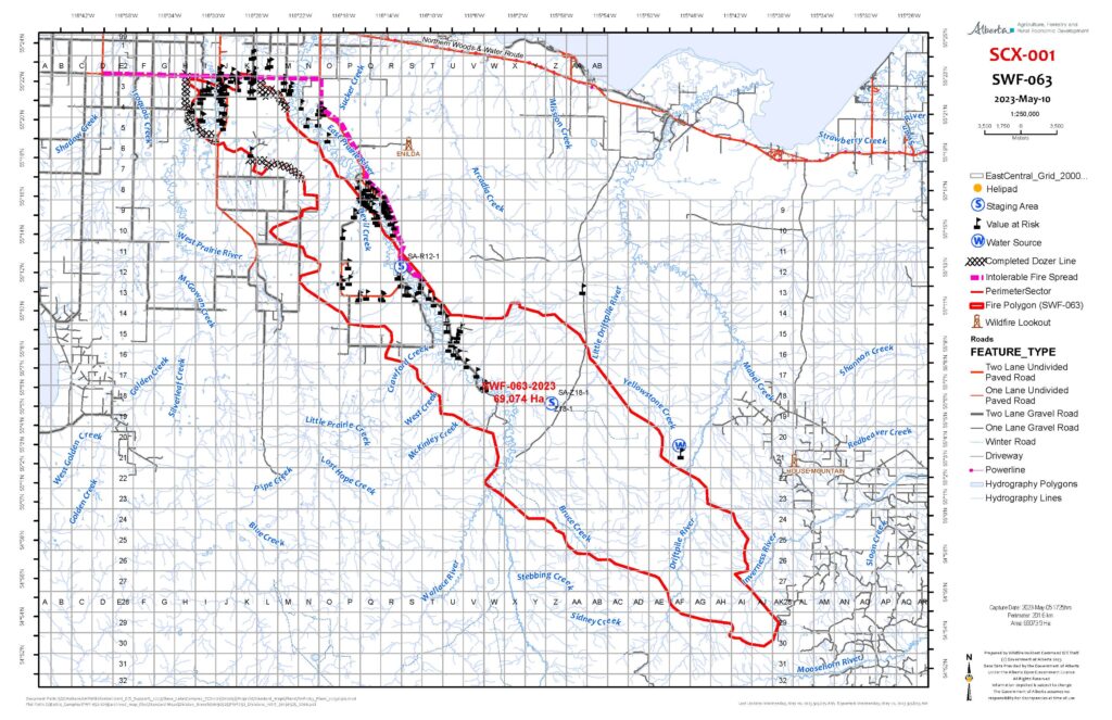
SWF-063 (East Prairie, Gilwood & Banana Belt Wildfire) – located approximately seven kilometers south of High Prairie and approximately 16 kilometres northwest of Swan Hills is classified as burning out of control and has burned an estimated 69,074 hectares. Due to winds from the northwest, the wildfire did experience some growth to the southeast. In the late afternoon, smoke suppressed the fire intensity. Firefighters are assessing ignition opportunities to create fire guards. Firefighters continued to work in areas around and within the East Prairie Metis Settlement and on the north side of the wildfire in the rural areas near the community of High Prairie. There are 50 firefighters and two heavy equipment groups working on this wildfire.
SWF-064 (Blue Lake Wildfire) – is located over 40 kilometers northwest of Swan Hills, is classified as out of control and has burned approximately 22,222 hectares. Smoky conditions prevented firefighters from observing the wildfire today and all firefighting efforts were focused on SWF063 and SWF057. There are two heavy equipment groups working on this wildfire.
SWF068 – The Kimiwan Complex/Peavine Wildfire (SWF068 and PWF038) – is classified as Out of Control (OC). Strong gusting wends yesterday evening and overnight resulted in this wildfire’s growth south and east by about 26,000 ha. It is estimated to be approximately 90,000 ha in size. Peavine Metis Settlement is under a mandatory evacuation notice due to the fire’s activity on the southwest flank. The wildfire’s north perimeter is approximately 38 kilometers south of Cadotte Lake and 39 kilometers south of Little Buffalo. PWF038 is also OC, and approximately 6,207 ha. It has remained relatively stable, with wildland firefighters patrolling and putting out hotspots to maintain containment lines.
Smoky conditions
Due to the numerous wildfires in Alberta, smoky conditions will persist in communities and along highways. Anyone with health concerns should visit Alberta Health Services or call 811 for health advice from Alberta Health Link. Before travelling check www.511.Alberta.ca for information the latest road conditions or closures. Visit www.firesmoke.ca to see where the smoke is coming from and to view wildfires on a map, download the AB Wildfire App or visit the Alberta Wildfire Status Dashboard.
Wildfire Danger
The wildfire danger is EXTREME in the Slave Lake Forest Area and Peace River Forest Area. With the return of extremely warm temperatures and gusty winds, firefighters urge everyone to continue to use caution as a fire will ignite easily and spread quickly. There is a Fire Ban and OHV Restriction in effect. visit www.albertafirebans.ca. Report wildfires immediately by calling 310-FIRE(3473).
Reporting wildfires
We have firefighters in aircraft working on the out of control wildfires and fire lookouts watching for smoke. While we always appreciate people calling in to report wildfires, the large volume of calls we are currently receiving is diverting our resources away from fighting wildfires. As always, please still call 310-FIRE if you see smoke or flame that looks new and potentially unreported, but assume that large columns of smoke and burned over areas have already been detected and reported.
On Alert
With the recent lightning, we may see new wildfire starts especially lightning holdovers in the days to come. Fire lookouts are on high alert constantly watching for smoke and firefighters in helicopters, various pieces of heavy equipment and airtankers are ready to respond to any new wildfires that may start.
Alberta Emergency Alert
A provincial state of emergency has been declared for Alberta. Critical alerts and advisories have been and could be issued for communities around active wildfires. Visit http://www.alberta.ca/emergencyalert for details. Albertans who require assistance can also call 310-4455 for evacuation related information.
Be Prepared
Learn about wildfires and what you can do to be prepared. Visit https://www.alberta.ca/wildfire-preparedness.aspx
MAY 15 @ 1:00 PM – WILDFIRE UPDATE
Wildfire Situation
On all out of control wildfires in the Slave Lake Forest Area, firefighting will be challenging as fire behaviour will be increased due to hot, dry and windy conditions. Firefighters, aircraft and heavy equipment are focusing on all critical areas of these wildfires.
There are now seven out of control wildfires in the Slave Lake Forest Area.
Grizzly Complex – SWF057 (Grizzly Ridge Wildfire), SWF063 (East Prairie, Gilwood & Banana Belt Wildfire), SWF064 (Blue Lake Wildfire)
The hot, dry conditions resulted in increased fire behavior across all wildfires in the Grizzly Complex yesterday. Firefighters, aircraft and heavy equipment continue to action hotspots and flare ups, as well as building fire guards in critical areas. With the south/southeast winds yesterday the wildfires did not experience significant growth. In total there are 88 firefighters,14 helicopters and six heavy equipment groups working on the Grizzly complex wildfires.
Due to the southern winds today, smoky conditions will persist in the are around the Town of High Prairie and along Highway 33.
SWF-057 (Grizzly Ridge Wildfire) – located approximately 26 kilometres south of Kinuso and over 30 kilometers southwest of the Town of Slave Lake, is classified as out of control and has burned an estimated 8,136 hectares. There was increased fire activity observed yesterday, and firefighters were working on flare ups along the east and south flanks of this wildfire. Firefighters continue to work with a nodwell and heavy equipment along the west portion of the wildfire (near highway 33) and today, firefighters will be establishing hose line in this area. The wildfire did cross the established fire guards in some areas yesterday. Firefighters with helicopters bucketing will be focusing on these locations today and heavy equipment will continue to build fire guard on the southeast portion of the wildfire. There are 29 firefighters and two heavy equipment groups working on this wildfire.
SWF-063 (East Prairie, Gilwood & Banana Belt Wildfire) – located approximately seven kilometers south of High Prairie is classified as burning out of control and has burned an estimated 69,074 hectares. Firefighters have been working on flare ups in the northeast portion of the wildfire as well as working with helicopters and airtankers in the East Prairie Metis Settlement area. Firefighters will continue to focus on addressing hot spots in the Banana Belt / East Prairie Metis Settlement areas today. The wildfire crossed the fire guard and retardant line in some areas of the wildfire and today additional heavy equipment groups will be moved into these areas to re-establish the fire guard. Firefighters will continue working along the Enilda road, toward East Prairie Metis Settlement with support of the local fire department. Firefighters and helicopters are also working on hotspots on the lower eastern flank of the wildfire. There are 50 firefighters and two heavy equipment groups working on this wildfire.
SWF-064 (Blue Lake Wildfire) – is located over 40 kilometers northwest of Swan Hills, is classified as out of control and has burned approximately 22,398 hectares.In the late afternoon yesterday, firefighters observed an increase in fire activity in the north end of the wildfire however there was no significant growth. Firefighters will continue to monitor this wildfire from the air and heavy equipment will continue to build fire guard. There are two heavy equipment groups working on this wildfire.
Click here to view a map of the Grizzly Complex.
SWF068 & PWF038 (Kimiwan Complex Wildfire/Peavine) – is a provincial Wildfire of Note and is currently classified as Out of Control (OC). It is estimated to be approximately 64,000 ha in size. Wildland firefighters are working to contain this fire after it was increasingly active again yesterday. Peavine Metis Settlement is under a mandatory evacuation notice due to the fire’s activity on the sourthwest flank. A forecasted low pressure system is expected to bring NW winds tomorrow or Tuesday. The wildfire’s north perimeter is approximately 38 kilometers south of Cadotte Lake and 39 kilometers south of Little Buffalo. It is currently being driven to the north by southerly wind.
Fire Ban & Off-Highway Vehicle Restriction
A Fire Ban and OHV Restriction is in effect for the entire Forest Protection Area of Alberta, including the Slave Lake Forest Area Wildfire Update and Peace River Wildfire Update.
A fire ban and OHV restriction remains in effect. Firefighters urge everyone to continue using caution and to report wildfires immediately by calling 310-FIRE (3473).
Smoky conditions
Due to the numerous wildfires in Alberta, smoky conditions will persist in communities and along highways. Anyone with health concerns should visit Alberta Health Services or call 811 for health advice from Alberta Health Link. Before travelling check www.511.Alberta.ca for information the latest road conditions or closures. Visit www.firesmoke.ca to see where the smoke is coming from and to view wildfires on a map, download theAB Wildfire App or visit theAlberta Wildfire Status Dashboard.
Wildfire Danger is EXTREME
The wildfire danger is EXTREME in the Slave Lake Forest Area. With the return of extremely warm temperatures and gusty winds, firefighters urge everyone to continue to use caution as a wildfire will ignite easily and spread quickly. There is a Fire Ban and OHV Restriction in effect. visit www.albertafirebans.ca. Report wildfires immediately by calling 310-FIRE(3473).
Reporting wildfires
We have firefighters in aircraft working on the out of control wildfires and fire lookouts watching for smoke. While we always appreciate people calling in to report wildfires, the large volume of calls we are currently receiving is diverting our resources away from fighting wildfires. As always, please still call 310-FIRE if you see smoke or flame that looks new and potentially unreported, but assume that large columns of smoke and burned over areas have already been detected and reported.
For updates on the locations of active fires in our region, please visit bit.ly/3OcBlIo.
May 14 @ 11:00 AM
WILDFIRE UPDATE
Wildfire Situation
On all out-of-control wildfires in the Slave Lake Forest Area firefighting will be challenging as fire behaviour will be increased due to hot, dry, and windy conditions. Firefighters, aircraft, and heavy equipment are focusing on all critical areas of these wildfires.
Grizzly Complex – SWF057 (Grizzly Ridge Wildfire), SWF063 (East Prairie, Gilwood & Banana Belt Wildfire), SWF064 (Blue Lake Wildfire) – The hot, dry conditions resulted in increased fire behavior across all wildfires in the Grizzly Complex. Firefighters, aircraft, and heavy equipment are actioning hotspots and flare-ups, as well as building fire guards in critical areas. There are 68 firefighters,13 helicopters, and five heavy equipment groups working on these wildfires. An additional 20 firefighters from the USA are expected to arrive today.
SWF-057 (Grizzly Ridge Wildfire) – located approximately 26 kilometers south of Kinuso and over 30 kilometers southwest of the Town of Slave Lake, is classified as out of control and has burned an estimated 8,136 hectares. Terrain is challenging for the sections of this wildfire, with steep ridges making access difficult for firefighters and heavy equipment. There was increased fire activity observed yesterday, overall the wildfire held well. Airtankers laid retardant lines on the north end and firefighters worked on the south, south-east portion of the wildfire with helicopter bucket support on perimeter. Heavy equipment continues to build fire guard along the west to south side of the wildfire and firefighters continue to secure the guard by extinguishing the wildfire’s perimeter while helicopters are bucketing on flare-ups. There are 28 firefighters and two heavy equipment groups working on this wildfire.
SWF-063 (East Prairie, Gilwood & Banana Belt Wildfire) – is located approximately seven kilometers south of High Prairie is classified as burning out of control and has burned an estimated 69,074 hectares. There were excursions from the wildfire’s perimeter yesterday and flare-ups resulting from increased fire behaviour, these were primarily on the northwest portion of the wildfire and in the East Prairie Metis Settlement and in the Banana Belt areas. Firefighters and helicopters bucketing worked on the areas of flare up, heavy equipment is re-establishing the fire guard and airtankers have laid retardant on the south end of the wildfire. There are 29 firefighters, and two heavy equipment groups are working on this wildfire.
SWF-064 (Blue Lake Wildfire) – is located over 40 kilometers northwest of Swan Hills, is classified as out of control, and has burned approximately 22,398 hectares. Heavy equipment groups continue to build fire guard around the northwest portion of the wildfire. There are three heavy equipment groups are working on this fire.
Wildfire Smoke
Due to the numerous wildfires in Alberta, smoky conditions will persist. Visit www.firesmoke.ca to see where the smoke is coming from and to view wildfires on a map, download theAB Wildfire App or visit the Alberta Wildfire Status Dashboard.
Wildfire Danger
The wildfire danger is EXTREME in the Slave Lake Forest Area. With the return of extremely warm temperatures and gusty winds, firefighters urge everyone to continue to use caution as a wildfire will ignite easily and spread quickly. Report wildfires immediately by calling 310-FIRE(3473).
Reporting wildfires
We have firefighters in aircraft working on the out-of-control wildfires and fire lookouts watching for smoke. While we always appreciate people calling in to report wildfires, the large volume of calls we are currently receiving is diverting our resources away from fighting wildfires. As always, please still call 310-FIRE if you see smoke or flame that looks new and potentially unreported, but assume that large columns of smoke and burned-over areas have already been detected and reported.
Fire Ban and Off-Highway Vehicle Restriction in Effect
A fire ban and off-highway vehicle restriction REMAINS in effect within the Forest Protection Area due to extreme fire danger.
MAY 13 @ 10:30 AM
WILDFIRE UPDATE
Grizzly Complex – SWF057 (Grizzly Ridge Wildfire), SWF063 (East Prairie, Gilwood & Banana Belt Wildfire), SWF064 (Blue Lake Wildfire)
As a result of the warm, dry conditions yesterday an increase in fire intensity was observed on the Grizzly Complex wildfires, although minimal growth was noted. This intensity is anticipated to increase in the upcoming days. Firefighters, aircraft and heavy equipment groups continue to build guards and address hot spots as they flare up. Updated wildfire perimeter mapping is also expected to be conducted today. There are 65 firefighters, seven heavy equipment groups and 12 helicopters working on these wildfires.
SWF-057 (Grizzly Ridge Wildfire) – located approximately 26 kilometres south of Kinuso and over 30 kilometers southwest of the Town of Slave Lake is classified as out of control and has burned an estimated 8,337 hectares. Heavy equipment continues to build fire guard along the west to south side of the wildfire and firefighters continue to secure the guard by extinguishing the wildfire’s perimeter while helicopters are bucketing on flare ups. This guard is approximately 95% complete in this area and they are making steady progress. Firefighters are also working on the north side of the wildfire with helicopter bucket support. Smoke from this wildfire is expected to be visible from Highway 33 today.
SWF-063 (East Prairie, Gilwood & Banana Belt Wildfire) – is located approximately seven kilometers south of High Prairie is classified as burning out of control and has burned an estimated 69,074 hectares. Firefighters, helicopter bucket support and nodwells focused on the northwest portion of the fire, working in the East Prairie Metis Settlement and Banana Belt areas to address hotspots and flare ups as well as continuing to secure the perimeter in the area between High Prairie and East Prairie Metis Settlement. Heavy equipment continues to build fire guard around the northwest side of the wildfire, as well as near East Prairie River and helicopters continue to address hotspots with buckets.
SWF-064 (Blue Lake Wildfire) – is located over 40 kilometers south of the Town of High Prairie, is classified as out of control and has burned approximately 22,398 hectares. The heavy equipment group continues to build fire guard around the northwest portion of the wildfire.
WILDFIRE DANGER
The wildfire danger has climbed to EXTREME in the
Slave Lake Forest Area.
Although we had some rain in the area, the amount is not significant enough to improve the overall dry conditions we have been facing.
REPORTING WILDFIRES – A MESSAGE FROM ALBERTA WILDFIRE
We have firefighters in aircraft working on the out-of-control wildfires and fire lookouts watching for smoke. While we always appreciate people calling in to report wildfires, the large volume of calls we are currently receiving is diverting our resources away from fighting wildfires. As always, please still call 310-FIRE if you see smoke or flame that looks new and potentially unreported, but assume that large columns of smoke and burned-over areas have already been detected and reported.
ATCO UPDATE
ATCO’s restoration is underway for the Banana Belt area and crews were working to have the power in the area restored by 8:00 PM, May 12.
In order to restore power to the Banana Belt area, temporary outages may occur, and some residents may see some disruptions while the work is being completed.
FIRE BAN AND OFF-HIGHWAY VEHICLE RESTRICTION IN EFFECT
The Fire Ban and Off-Highway Vehicle restriction REMAINS IN EFFECT within the Forest Protection Area due to extreme fire danger. The fire ban and OHV restriction will remain in effect until conditions improve. More details, https://bit.ly/41MkPSF.
MAY 12 @ 2:30PM
WILDFIRE UPDATE
SWF-057 Wildfire (Grizzly Ridge Wildfire), SWF-063 Wildfire (East Prairie, Gilwood, and Banana Belt) and SWF-64 (Blue Lake) are still classified as out of control. The wildfires did not experience any significant growth and fire intensity was reduced due to some isolated showers that passed over SWF-057 and SWF-063 yesterday afternoon. A 20-person Incident Management Team and 40 firefighters arrived from Ontario and are being deployed on the wildfires today. The evacuation ALERTS for both the Town of High Prairie (4-hour notice) and Big Lakes County (1-hour notice) remain in place.
SWF-057 (Grizzly Ridge) – is located approx. 26 km south of Kinuso, is classified as out of control and has burned an estimated 8,337 hectares. Firefighters and helicopter bucket support focused on putting up a guard on the southwest portion of the fire (90% complete in this area), and will finish today. Heavy equipment continues to build fire guard along the west to south side of the wildfire and firefighters continue to secure the guard by extinguishing the wildfire’s perimeter while helicopters are bucketing on flare ups. This guard is approximately 90% complete in this area and expected to be completed today. Firefighters have placed over 3000 feet of hose along this section. There has been approx. 2km of fire-retardant line placed along the ridge on the Southeast side (by Hwy 33). There are ten firefighters and two heavy equipment groups working on this wildfire. There are 13 helicopters assigned to the Grizzly complex as well.
SWF-063 (East Prairie, Gilwood, and Banana Belt) – is located approximately seven kilometers south of High Prairie is classified as burning out of control and has burned an estimated 69,074 hectares. Firefighters and helicopters worked in the northeast portion of the wildfire to extinguish a slash pile fire in the Banana Belt area. Firefighters with nodwells and helicopters are working on flare ups and hot spots around the community of East Prairie Metis Settlement. Heavy equipment continues to build fire guard around the east side of the wildfire and helicopters continue to hit hotspots with buckets. There are 30 firefighters and four heavy equipment groups working on this wildfire. There are 13 helicopters assigned to the Grizzly complex as well.
SWF-064 (Blue Lake) – is located approx. 40 km southeast of the Town of High Prairie, is classified as out of control and has burned approximately 22,398 hectares. A heavy equipment group continues to build fire guard around the northwest portion of the wildfire.
ALBERTA EMERGENCY ALERTS
Over the weekend, you will continue to receive notifications from Alberta Emergency Alert. Since these alerts expire every 24 hours, we will need to keep sending them out so residents are informed of the status of the wildfires. Please continue to read these alerts, as they may change throughout the weekend.
ATCO ELECTRIC
ATCO Electric is busy restoring power in East Prairie, Gilwood, and the Banana Belt areas. There are crews from ATCO Fort Mac who are currently working on restoring power along HWY 749 in the Banana Belt area.
RECEPTION CENTRE
Since there is not a mandatory evacuation order for Big Lakes County, the Reception Centre at the High Prairie Elks Rodeo Hall will be closing down and not taking any more registrations, effective May 12, 2023, at 8PM. East Prairie Metis Settlement residents who are still under mandatory evacuation who have not registered, please visit https://emergencyregistration.alberta.ca. A HUGE thank you to the Big Lakes FCSS staff for their hard work and dedication in running the Reception Centre at the Elks Rodeo Hall.
FIRE BAN AND OFF-HIGHWAY VEHICLE RESTRICTION IN EFFECT
A fire ban and Off-Highway Vehicle restriction is in effect within the Forest Protection Area due to extreme fire danger. The fire ban and ohv restriction will remain in effect until conditions improve. More details, https://bit.ly/41MkPSF
May 13 @ 4:45 PM – This is an Alberta Emergency Alert. Big Lakes County has issued an Evacuation Order due to Wildfire. This alert is in effect for Big Lakes County residents south of Township Road 740, west of Range Road 152, east of Range Road 162 and north of Township Road 730.
A fire southeast of the Town of High Prairie is moving northeast. If you are in the effected area you must evacuate immediately. Bring pets, important documents, medication, and supplies for 7 days. Everyone evacuating should go to the Elks Rodeo Hall north of the Town of High Prairie at 74508 on Highway 749 to register. Everyone must evacuate now.
Bring RV’s if you have them as camping is available on-site at the Elks Rodeo Hall. Stay tuned to www.alberta.ca/emergencyalert and local media for updates.
May 13 @ 10AM – ATCO’s restoration is underway for the Banana Belt area and crews were working to have the power in the area restored by 8:00 PM, May 12.
In order to restore power to the Banana Belt area, temporary outages may occur, and some residents may see some disruptions while the work is being completed.
This update is for the wildfire that affected East Prairie, Banana Belt, Gilwood, and Snipe Lake.
MAY 10 @ 1PM – The wildfire danger has climbed to HIGH in the Slave Lake Forest Area for May 10th.
Our fire crews continue to build structure protection plans to mitigate potential damages to the entire community affected by the 3 ongoing wildfires within our County boundaries.
With the return of warm temperatures, we urge everyone to continue to use caution and to report wildfires immediately by calling 310-FIRE(3473). If your home is directly being threatened by fire, please call 911.
Be mindful that a Fire Ban and OHV Restriction is in effect and will remain in effect until conditions improve.
Our local firefighters from Big Lakes County and Alberta Forestry are still battling the ongoing wildfires in our area. The evacuation ALERTS for both the Town of High Prairie (4-HOURS) and Big Lakes County (1-HOUR) remain in place.
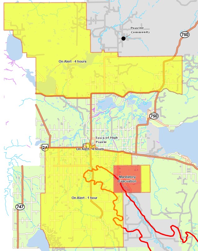
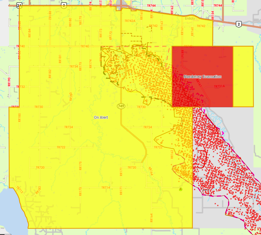
The SWF-063, East Prairie wildfire is currently estimated to have affected an area of around 69,000 hectares. The red shape on the map below represents the approximate area where the firefighters have been actively protecting residential properties. Please note that this is just an ESTIMATION and that the actual affected area continues to be monitored.
Firefighters have been prioritizing the protection of structures while responding to the wildfires. It’s important to note that not all structures in the affected fire area have been impacted.
The crews are planning to conduct a formal assessment of the properties that have been affected by the wildfires. However, this assessment will be carried out as soon as the conditions allow them to do so.
May 8 @ 2:30pm – There are currently three (3) fires burning in Big Lakes County: Grizzly Ridge, East Prairie (Enilda, Banana Belt, and Gilwood), and Blue Lake.
Please be aware that Big Lakes County Fire Services and Alberta Wildfires are still actively fighting the fires. The County will be conducting an assessment of fire affected structures and will have more information regarding any damage or losses in the coming days. Please do not drive over any inflated hose lines or interfere with any equipment that is set up. This is still an active fire, and the State of Local Emergency remains in place. While weather conditions have improved, please be on alert for any weather changes, as the situation could change quickly. If you spot fire flare ups on your property, please call 310-FIRE IMMEDIATELY.
A 1 HOUR evacuation alert remains in effect for Big Lakes County residents in the Enilda, Gilwood, and Banana Belt areas. This means that residents can safely return to their properties but must be PREPARED to evacuate should an evacuation order be issued.
Highway 749 is open. There will be lane restrictions, speed reductions, and flag persons on site to monitor safety while ATCO conducts operations to restore power in the area. PLEASE be respectful of the worker’s safety and SLOW DOWN as they make efforts to restore utilities to the area.
A boil water advisory is still in effect for the Riverbend Co-op Water System. This advisory ONLY AFFECTS the Riverbend pumphouse in the Gilwood area located on Highway 749, South of Township Road 740 and along Township Road East of Highway 749.
Big Lakes County would like to thank our community members who have responded with such understanding and support – especially towards our Fire Services staff and our dedicated VOLUNTEER FIREFIGHTERS. Residents who have suffered their own losses in so many ways, yet have responded overwhelmingly with patience, goodwill, calmness, kindness, and support. We thank you for your understanding.
Over the next few days and weeks, we will continue to keep you informed through our website and Facebook page. We have also set up an email address, should you have any wildfire questions at [email protected].
MAY 7 @ 8:50PM – Big Lakes County mandatory evacuation ORDER has been downgraded to an ALERT. The Evacuation ORDER has been reduced to a 1 HOUR Evacuation ALERT as shown in the attached map.
Highway 749 remains closed until further notice for safety concerns due to downed powerlines.
There remains large areas within the affected area with NO ELECTRICAL POWER AND NO NATURAL GAS SERVICES. The providers are aware of and are working to resolve these outages.
THE RISK OF WILDFIRE REMAINS due to continuing isolated ground fires. BE aware of possible flare-ups as temperatures and winds continue to pose a risk.
CONTINUAL UPDATES WILL BE PROVIDED.
MAY 7 @ 6:30PM – Enilda, Gilwood, and Banana Belt Residents who are under mandatory evacuation.
Big Lakes County is in the process of developing a re-entry plan in coordination with ATCO Electric and Prairie River Gas. Re-entry to the various areas affected by the fire is complex due to the power and natural gas line disruptions/damage. Utility companies are assessing every property and the utility infrastructure affected by the fires to determine when it will be safe for residents to re-enter.
The County understands that residents are anxious to return; however, we want to ensure it is done safely. If you are under mandatory evacuation, you are required to leave immediately and not return home until further notice.
We will have more updates for you tomorrow morning.
SNIPE LAKE WILDFIRE
MAY 6 @ 4PM – There is a wildfire moving northwest towards the Snipe Lake Area. Since there is the potential for danger to life and health, Big Lakes County has issued an evacuation alert for Gilwood south and west Banana Belt residents from Highway 749 west to Range Road 190 and Township Road 730 south to Township Road 714.
If you are in the following areas, you must prepare to evacuate. The areas involved are as follows:
Highway 749 west to Range Road 190 and Township Road 730 south to Township Road 714.
Livestock Producers, please consider marking your animals in a unique way. If you have access to discing equipment, please start creating fire breaks around your property. Wet down buildings and bale stacks. If you have any questions or concerns, please contact the Big Lakes Agricultural Fieldman at 780-523-8249.
Further instructions will be given to those directly impacted. Citizens are to monitor www.biglakescounty.ca, the Big Lakes County Facebook page, and the Alberta Emergency Alert website for additional information.
MAY 6 @ 3:30PM – There is a wildfire moving northwest towards the Snipe Lake Area. Since there is the potential for danger to life and health, Big Lakes County has ordered Gilwood south and west Banana Belt residents from Range Road 183 west to Range Road 162 and from Township Road 714 south to Township Road 710 to evacuate immediately.
If you are in the following areas, you must evacuate. The areas involved are as follows:
Range Road 183 west to Range Road 162 and from Township Road 714 south to Township Road 710
Livestock Producers, please mark your animals in a unique way, open gates or leave temporary fencing to create areas that animals can freely move to avoid the fire, open fence lines so animals can get into creeks or dugouts, and close building accesses so animals won’t become trapped. If you have access to discing equipment, please start creating fire breaks around your property. Wet down buildings and bale stacks. If you have any questions or concerns, please contact the Big Lakes Agricultural Fieldman at 780-523-8249.
Bring pets, important documents, medication, and supplies for 3 days. Everyone evacuating should go to the Elks Rodeo Hall north of the Town of High Prairie at 74508 on Highway 749 to register. Further instructions will be given to those directly impacted. Citizens are to monitor www.biglakescounty.ca, the Big Lakes County Facebook page, and the Alberta Emergency Alert website for additional information.
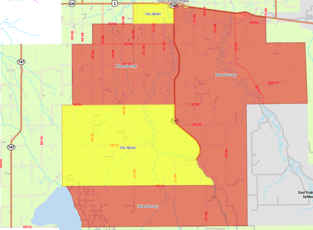
GILWOOD WILDFIRE
MAY 7 @ 4PM – Big Lakes County Fire Services will be assessing every property effected by the wildfire ensuring that the fire has been properly extinguished around each property. We do not have a definitive answer as to which properties have been affected by the wildfire.
The map below shows the wildfire boundary. Please note, this is an estimation from Alberta Wildfire as to where the fire boundary is.
The current weather conditions are in our favor. However, we are still assessing the wildfire movements. Please respect the mandatory evacuation order. We will inform you when it is safe to return back to your property.

May 6 @ 8:15 PM – This is an Alberta Emergency Alert. Big Lakes County is issuing a Wildfire Alert. This alert is in effect for Big Lakes County Residents in the area: South of Highway 2, East of Range Road 185, North of Township Road 740, West of Range Road 183, and West of Highway 749.
A wildfire is moving northwest through the Gilwood area. Since there is a potential danger to life and health, if you are in the affected area, you must PREPARE to evacuate with 1 HOUR notice. Gather pets, important documents and medication, and enough food, water, and supplies for at least 3 days. This alert will be updated if an evacuation is required. Stay tuned to www.alberta.ca/emergencyalert and local media for updates.
____________________________________________________________________________________________________
May 6 @ 1:18 PM -This MANDATORY EVACUATION Order is in effect for Big Lakes County residents in the Gilwood area located between Highway 749 west to Range Road 185 and from Township Road 730 north to Township Road 740.
A wildfire is moving west parallel to Township Road 740. Since there is the potential for danger to life and health, if you are in the affected area, you must evacuate IMMEDIATELY.
Bring pets, important documents, medication, and supplies for 3 days. Everyone evacuating should go to the Elks Rodeo Hall north of the Town of High Prairie at 74508 on Highway 749 to register. Stay tuned to www.alberta.ca/emergencyalert and local media for updates.
____________________________________________________________________________________________________
May 6 @ 9:30 AM -This is an Alberta Emergency Alert. Big Lakes County is issuing a Wildfire Alert. This alert is in effect for Big Lakes County Residents In the area: West of Range Road 175, North of Township Road 734, East of Range Road 183, South of Township 742, West of Highway 749, North of Township Road 740.
A wildfire is moving west through the Gilwood area. Since there is potential danger to life and health, if you are in the affected area, you must PREPARE to evacuate with 60 minutes notice. Gather pets, important documents and medication, and enough food, water, and supplies for at least 3 days. This alert will be updated if an evacuation is required. Stay tuned to www.alberta.ca/emergencyalert and local media for updates.
____________________________________________________________________________________________________
MAY 6 @ 9AM – This MANDATORY EVACUATION Order is in effect for Big Lakes County residents North of Township Road 734, East of Range Road 175, West of Highway 749, and South of Township Road 740. A wildfire is moving west parallel to Township Road 740. Since there is the potential for danger to life and health, if you are in the affected area, you must evacuate IMMEDIATELY.
Bring pets, important documents, medication, and supplies for 3 days. Everyone evacuating should go to the Elks Rodeo Hall north of the Town of High Prairie at 74508 on Highway 749 to register. Stay tuned to www.alberta.ca/emergencyalert and local media for updates.
BANANA BELT WILDFIRE
May 6 @ 6:45am – This is an Alberta Emergency Alert. Big Lakes County is issuing a Wildfire Alert. This alert is in effect for Big Lakes County residents North of Township Road 734, East of Range Road 175, West of Highway 749, and South of Township Road 740. A wildfire is moving northwest through the Banana Belt area. Since there is the potential for danger to life and health, if you are in the affected area, you must PREPARE to evacuate with 60 minutes notice. Gather pets, important documents and medication, and enough food, water, and supplies for at least 3 days. This alert will be updated if an evacuation is required. Stay tuned to www.alberta.ca/emergencyalert and local media for updates.
May 6 @ 1:30am – This is an Alberta Emergency Alert. Big Lakes County has issued an Evacuation Order due to Wildfire. This alert is in effect for Big Lakes County residents north of Township Road 740 within the borders of Range Road 154, Highway 749, and south of Highway 2, including the Hamlet of Enilda, as outlined on the map. A fire within East Prairie Metis Settlement is moving northwest. The area of Township Road 740 within the borders of Range Road 154, Highway 749, and south of Highway 2 have a mandatory evacuation order has been extended to this area. Everyone in this area must evacuate now. Bring pets, important documents, medication, and supplies for 3 days. Everyone evacuating should go to the Elks Rodeo Hall north of the Town of High Prairie at 74508 on Highway 749 to register. Everyone must evacuate by 3:00 AM, May 6. Bring RV’s if you have them as camping is available on-site at the Elks Rodeo Hall. Stay tuned to www.alberta.ca/emergencyalert and local media for updates.
May 6 @ 12:25am – This is an Alberta Emergency Alert. Big Lakes County has issued an Evacuation Order due to Wildfire. This alert is in effect for Big Lakes County residents within Township 73 and Range 15 and Township 73 Range 16 as outlined on the map. A fire within East Prairie Metis Settlement is moving northwest and is expected to reach the Banana Belt area overnight tonight. The Banana Belt Evacuation Order has been extended to these two townships. Everyone in these two townships must evacuate now. Bring pets, important documents, medication, and supplies for 3 days. Everyone evacuating should go to the Elks Rodeo Hall north of the Town of High Prairie at 74508 on Highway 749 to register. Everyone must evacuate by 1:00 AM, May 6. Bring RV’s if you have them as camping is available on-site at the Elks Rodeo Hall. Stay tuned to www.alberta.ca/emergencyalert and local media for updates.
May 5, 2023 @ 10:30pm – This is an Alberta Emergency Alert. Big Lakes County has issued an Evacuation Order due to Wildfire. This alert is in effect for everyone in Big Lakes County, east of the West Prairie River and Highway 749, and south of Township Road 724 as outlined by the map. A fire within East Prairie Metis Settlement is moving northwest and is expected to reach the Banana Belt area overnight tonight. Everyone east of the West Prairie River and Highway 749 and south of Township Road 724 must evacuate now. Bring pets, important documents and medication and supplies for 3 days. Everyone evacuating should go to the Elks Rodeo Hall north of the Town of High Prairie at 74508 on Highway 749 to register. Everyone must be evacuated by midnight tonight by 12:00 AM, May 6. Bring RV’s if you have them as camping is available on site at the Elks Rodeo Hall. Stay tuned to www.alberta.ca/emergencyalert and local media for updates.
MAY 5, 2023 @ 7PM – The wildfire southeast of East Prairie Metis Settlement has moved northwest into the East Prairie Metis Settlement and has the potential to reach the Banana Belt area. Since there is the potential for danger to life and health, Big Lakes County has ordered residents east of the West Prairie River and Highway 749 and south of Township Road 724, to prepare to evacuate.
If you are in the following areas, you must prepare to evacuate. The areas involved are as follows:
east of the West Prairie River and Highway 749 and south of Township Road 724
Banana Belt residents are asked to please FireSmart their properties by removing log piles, deadfall, and plowing around properties if possible. For more information, please visit, firesmartcanada.ca/homeowners/protect-your-home/ If you have questions regarding your livestock, please contact the Big Lakes County Agricultural Fieldman at 780-523-8249.
Alberta Wildfire and Big Lakes County Fire Services are monitoring the wildfire situation and are working with residents to prepare for evacuation.